|
|
|
The Early Days
The first visitor of record from Europe to set foot on what is now known as Florida was apparently Juan Ponce de Leon, a Spanish officer, in 1513. Florida was named Pascua Florida by explorer Ponce de Leon on Easter in 1513. Translation: means "Flowery Easter" or "Flowering Easter" (after Spain's "Feast of the Flowers" Easter celebration).From that time forward the territory known as Florida had been periodically subject to a few settlements, mostly Spanish and a few English, but no settlements on the barrier islands until after Spain ceded the Florida territory to the United States February 19, 1821. The original natives in the territory later known as the Treasure Coast were the Ais Indians who were at times hostile to the settlers encroaching into their territory. From 1763 to 1783 the territory had been under the dominion of Great Britain and known as East and West Florida with the Apalachicola River being the dividing line. By March 10, 1821, Major General Andrew Jackson was named Governor of the territories of East and West Florida. In the early 1800’s the Seminole Indians started moving south, displacing the Ais and also impeding the “take over” by the white men. The second Seminole War in 1835 pushed the Indians south and westward from the Treasure Coast. On March 3, 1845 Florida was “admitted to the Union on equal footing with the original States in all respects whatsoever.” It was the twenty-seventh state. The constitution adopted in 1845 is still in effect today.
As more and more people moved into Florida, population centers and governing bodies evolved. Originally Florida had 2 governing divisions within the state, namely Escambia and St. Johns and what became known as Hutchinson Island was in the latter. In the mid 1840’s there were 17 counties and the island was part of Mosquito County. Then in 1850 there were 28 counties and Hutchinson Island was in St. Lucie County. By 1880 there was more change, St. Lucie County disappeared and Hutchinson Island was in Brevard County. In 1975 St. Lucie County was carved out of Brevard County, that being the St. Lucie County we know today and which the Hutchinson Islands are a part of.
The first land owner of record of what we now know as North and South Hutchinson Islands was James A. Hutchinson, whose name adorns today’s islands. He came to Florida March of 1803 and petitioned the Spanish Governor of Florida for 2,000 acres, running from the Indian River inlet to Jupiter inlet. Initially, Spain had granted 2,000 acres on the mainland to him, but after several years of Indian difficulties (stealing his cattle, destroying crops, and molesting slaves) he requested that his grant be transferred to the barrier island (the undivided Hutchinson Island) for more natural protection. This request was granted in 1807. However, in 1809 he returned to St. Augustine by boat to complain about pirate raids and lost his life in a storm during his return trip. A grandson, John Hutchinson, returned to the island in 1843 and established a residence 6 miles south, of Ft. Pierce on the river side of the island. He was apparently attempting to establish an Indian River Colony, but it failed and he was never heard from after 1849.
North Hutchinson Island did not exist until the creation of the Fort Pierce Inlet, which opened May 10, 1921. The initial inlet was 1,400 feet long, 200 feet wide, and about 7 feet in depth. Later actions both widened the channel and tripled the depth to create a deep water port. Creation of the inlet physically divided Hutchinson Island to form what is now known as South Hutchinson Island or South Beach and North Hutchinson Island. As islands go, North Hutchinson Island is not a separate island because it is contiguous with Orchid Island in Indian River County with the two forming the barrier island that runs from the Fort Pierce Inlet to the Sebastian Inlet that was created in 1948. Before creation of the man-made inlets, there was a natural inlet in the middle of North Beach. That inlet was shallow and at times impassable.
What became known as the Treasure Coast was not known as such until after World War II when treasure hunters started retrieving the hidden contents, starting in1963, from a fleet of 11 Spanish ships (by some accounts, joined by one French ship) that got caught in a hurricane in 1715. All ships sank off the Florida coast, mostly along what is now Indian River and St. Lucie Counties. The Spanish Plate Fleet, also called a flotilla or flota, carrying 14,000,000 pesos in silver and a large consignment of gold and other valuables was headed for Spain from Cuba through the Canal de Bahama to pick up the Gulf Stream. The fleet left Havana July 24th and by July 30 encountered the hurricane that caused its demise. The Santissima Trinidad y Nuestra Senora de la Concepcion, captained by Captain General Don Juan de Ubilla, wrecked just 300 yards off shore near Pepper Park, very near where the old natural Indian River Inlet was located. That ship was also called the Urca de Lima. Urcas were a cargo frigate constructed with a flat bottom to better handle shallow coastal waters. It was also called the Nao de Refuerzo, possibly because of the way it was reinforced to handle the ocean. The Urca de Lima was not totally destroyed and all but 30 of its crew survived. They may have been joined by survivors from a sister ship that wrecked less than a mile north of the Urca. Stores were reportedly used by survivors for about a month until help arrived from Spain and some cargo salvaged. The remains were burned to prevent detection by "freebooters". Some 50 years later a British marine surveyor, Bernard Romans, who had been sent to map the coastline found the remains of the Urca de Lima, and some salvage of artifacts occurred. It wasn't until 1928 that an adventurer named William J. Beach arrived and efforts were initiated by Fort Pierce officials to investigate the Urca site and retrieve some of the larger items, like cannons and anchors, some of which adorn the Fort Pierce City Hall area today. The Urca site became the first Underwater Archaeological Preserve of Florida in 1987. A buoy about 1,000 yards north of Pepper Park marks the location where the wreck lies on the first off shore reef in 10-15 feet of water. A buoy at Pepper Park marks the location of the ships 15 foot anchor. The Urca was listed in the National Register of Historic Places in 2001. A second ship of the treasure fleet, the Nuestra Senora del Rosario sank several hundred yards north of the first one near today's Ocean Resorts CO-OP. This ship was a 150 foot long gallon of 471 tons and armed with 50 cannons. It faltered just 500 yards off shore with wreckage strewn eastward almost to the shoreline. An anchor, that matches 1700 era anchor designs, is located in Ocean Resorts. It may have been from that ship and was reportedly dredged up in the late 1990's when the Corp of Engineers were removing WW II military entrapments from the shoreline. While the foregoing is plausible, there is no authoritative verification currently available. From 1715 through 1719 Spanish salvage operations under Don Joseph Clemente Fernandez reportedly recovered almost 80% of the original treasure along the coastal wrecks. A total of six sunken ships from the fleet have been found off shore from just south of Fort Pierce north to Sebastian. It is believed that two others sank in deep water with one wrecked on the beach and subsequently salvaged. The other three have not yet been found. Some theorize that the treasure ships were seeking safety in the Indian River by going through the old Indian River Inlet on North Hutchinson Island slightly north of where the UDT Seal Museum is today. That inlet had been problematic for years due to drifting sand or shoaling and was apparently too shallow at the time of the storm for their passage. The inlet was originally 8-10 feet deep, but by 1856 had shoaled up to 3 feet and totally disappeared by 1911. There are also tails of how a Civil War era longboat with gold and money to pay troops capsized at the inlet with about thirty thousand dollars' worth of the gold found in the old inlet territory.
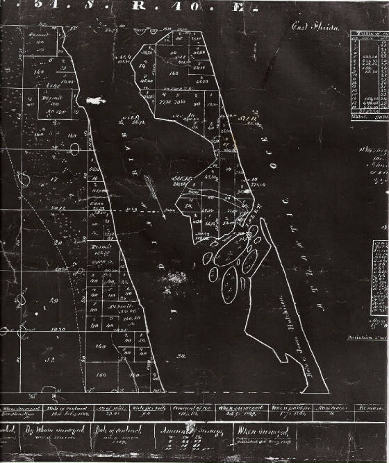
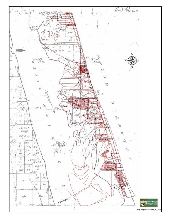
The black on white map picture that follows was from a survey of May 5, 1859, and it clearly shows the old natural inlet with numerous islands and shallows with no indication of it being navigable at that time. That map indicates that the inlet was in the vicinity of Ocean Harbour South and Oceanique Waterfront, although it likely extended southward as far as Ocean Pearl before the shoaling reduced the passage. Following the 1859 map is an overlay of a current map onto the old map to the same scale with sections matched to pinpoint the inlet location on the current landscape. The 1859 map is the black lines, with the current overlay map being the red lines. It is likely that today’s Kings Island, Wildcat Cove, and Jack Island Preserves are remnant islands of the old natural inlet. Disappearance of the natural inlet contributed to the eventual creation of the Fort Pierce inlet. There is a weather and time worn anchor of the kind used on the treasure ships located on the ocean side property of Ocean Resorts CO-OP. It is pictured at the Ocean Resorts section, but it is so time/weather worn that no identifying marks have been detected.
Probably the best known of the many treasure hunters was Mel Fisher. After World War II Mr. Fisher operated out of the Fort Pierce area and had an artifact museum in the Fort Pierce Treasure Building located on North Beach. There is some dispute that he used that building, but the majority of written history indicates that he did. That is the circular structure that ultimately became the south west part of the UDT-SEAL Museum. A picture of this circular building is located with the SEAL Museum discussion later in this history. Many of Mr. Fisher’s findings are still on display at museums in both Sebastian and Key West. Originally such treasures were “free for the taking” from the ocean, but the state of Florida eventually got into the act requiring salvage permits and imposing taxes.
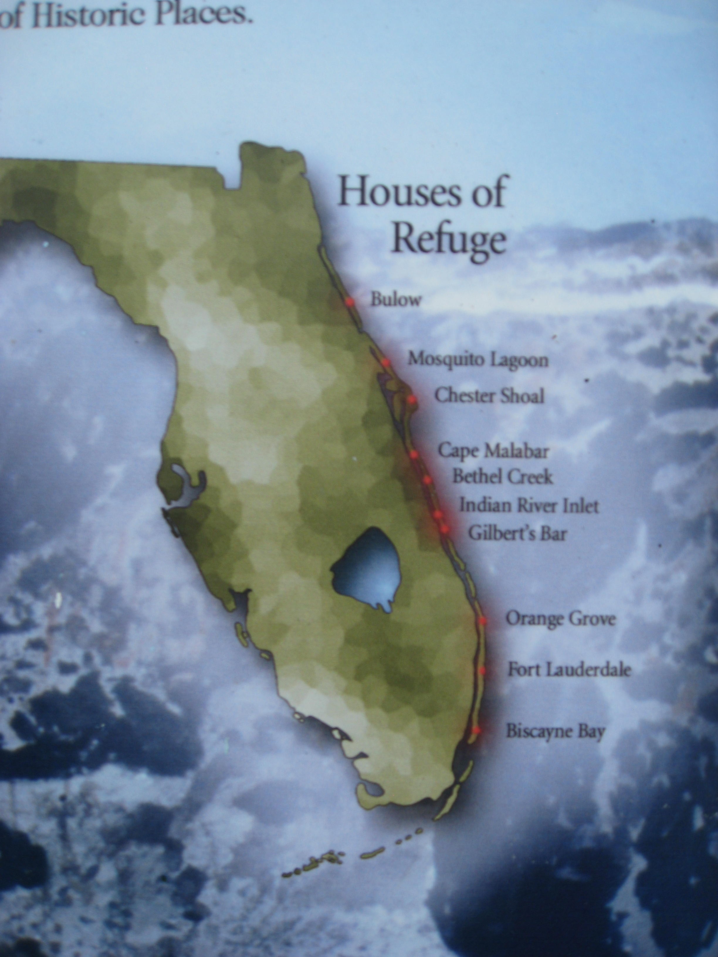
Because of the frequency of tropical storms and their stranding of ships along the sparsely populated coast line, the Federal government commissioned the building of ten (10) houses of refuge along the southern coast. These were built between 1876 and 1886. They were built to withstand hurricanes and were of identical design, with permanent caretaker housing on the first floor where there was a bedroom, kitchen, dining facility and stores. The second floor was housing (bunking) for those seeking refuge. The houses of refuge were spaced about 20 to 30 miles apart along the coast and cost $2,900 each. The map below shows the location of the houses of refuge.
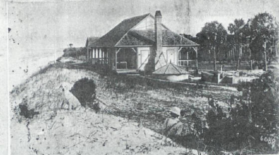
INDIAN RIVER HOUSE OF REFUGE
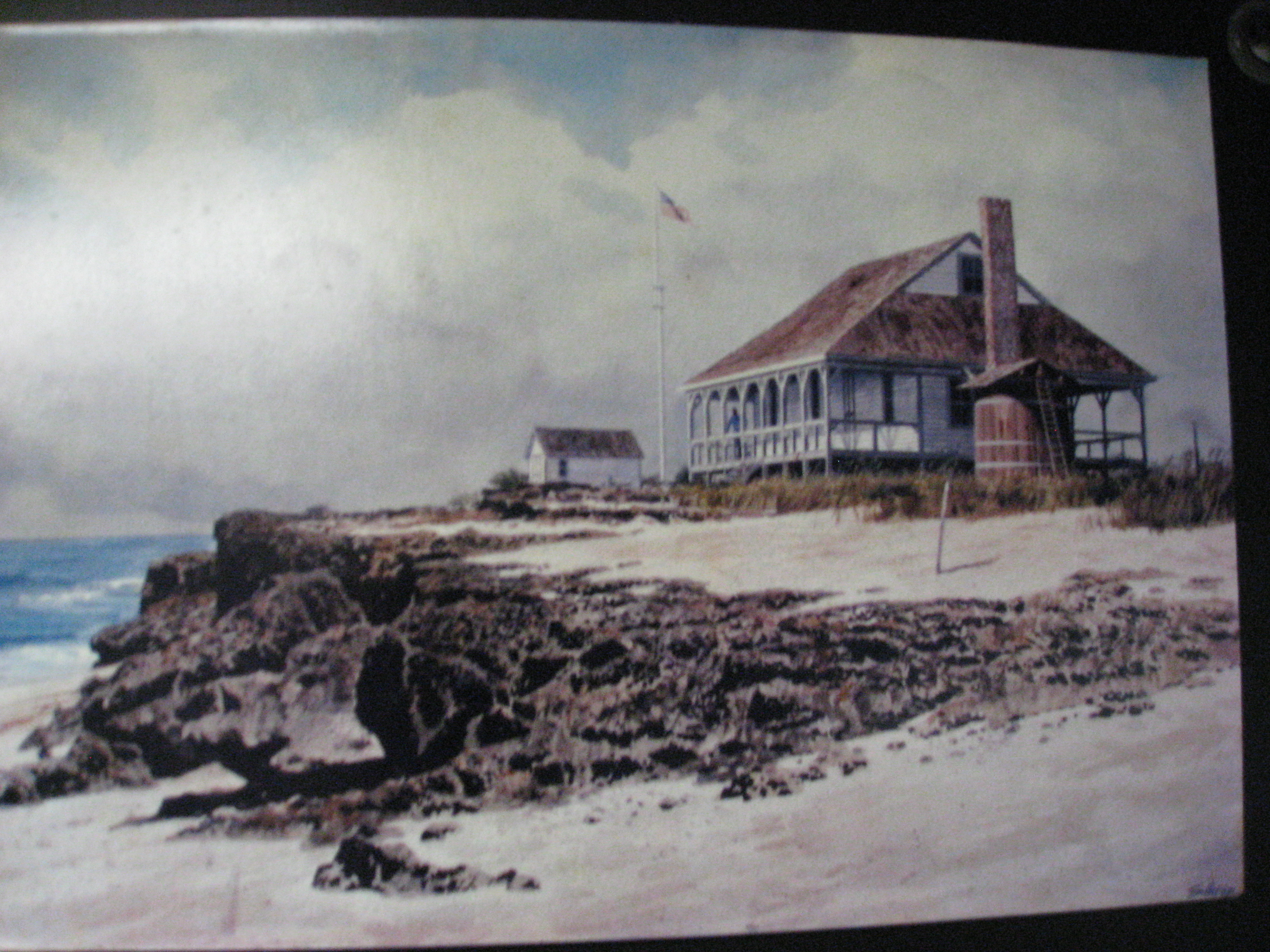
The stipend for the keeper was $400 per year plus allowance for provisions. One such house of refuge was located where Pepper Park is currently located. It was built in 1886 and called the Indian River House of Refuge. Its first keeper was James Bell and the house was thought to have been standing at the beginning of World War II as the only building on North Hutchinson Island. A written log from that house, loaned to the St. Lucie Historical Museum by Bob Miller, son of Ed Miller who was stationed at the house, shows 34 ship wrecks during the period of Oct. 28, 1887 to March 23, 1913. Many of these involved small boats such as fishing boats and schooners. Some say the house disappeared in the military training exercises that occupied the island during the war. Others say it was torn down immediately after the war because of its deteriorated condition. Only one of the ten houses of refuge remains today. It is called Gilbert’s Bar, is located on A1A near Stuart, and is open to the public as a museum.
Indian River House of Refuge Gilbert's Bar
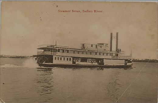
The western side of North Hutchinson Island is bounded by the Indian River. It has existed for as long as there are any records. As far as is known it has always been a salt water channel with tides and entrance/exit with the Atlantic Ocean. Some fresh water streams/rivers/creeks/canals empty into the Indian River. It is 121 miles long and stretches from Ponce de Leon inlet (Volusia County) in the north to St. Lucie inlet on the south. The Indian River is the northern portion of the Indian River Lagoon which also includes the Banana River and Mosquito Lagoon. The lagoon stretches for 156 miles. It has many shallow areas, its average depth being only about 3 feet with its width varying from ½ mile to 5 miles. It is reported to be the most diverse estuary known with more than 2200 species of animal life and nearly that many plant species. Stamboats like the one pictured plied the lagoon.
The intrusion of man has been altering the river/lagoon to such an extent that environmental management is a never ending challenge. Run offs carry both pesticides and fertilizer remnants into the lagoon and abnormal fresh water discharges from Lake Okeechobee (natural drainage was through the Everglades) all adversely affect the lagoon’s ecology. It has reached such an extent that what had been clear water is so clouded that one can only see bottom in depths of 6 inches unless an extended cold front cause particle precipitation temporarily and then extended cold temperatures cause a different problem for river inhabitants. The Atlantic Coast portion of the Intracoastal Waterway system traverses north-south through the Indian River Lagoon. That portion of the system was created in 1914 at a cost of about three and a half million dollars. It provided a channel with a depth of 22 feet. Many spoil islands were created along its length from the dredging’s that created the channel. These islands are among the many natural islands that also adorn the river. Some have remained in their natural state and are wildlife refuges, while others are maintained recreational areas. The Indian River portion of the Intracoastal system is a relatively small portion of the entire system which covers over 3,000 miles along the Atlantic and Gulf coasts.
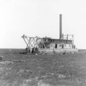
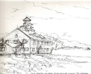
Hutchinson Island remained basically uninhabited until after the Fort Pierce inlet was opened in 1921. The inlet site was selected because of its proximity to Fort Pierce and the distance from ocean to lagoon being only a hundred yards. Also the original inlet was only about 4 feet deep and 100 feet wide. It was created strictly by state and local officials without involvement of the Army Corp of Engineers. In 1936 an enlargement project increased the depth to 30-40 feet and the width to 900 feet. The picture above shows the dredge used in the enlargement operation. Up until the inlet creation there was no bridging to the island and it remained a recreational spot for fishing and partying accessible only by boat. The first bridging to South Hutchinson Island was created shortly after WW I. Dredging from the building of the Fort Pierce inlet was added to the northwest portion of the island to create a causeway toward Fort Pierce and this was then connected to the mainland by a toll bridge dedicated January 19, 1926. One of the early structures on the island was a Coast Guard station pictured below.
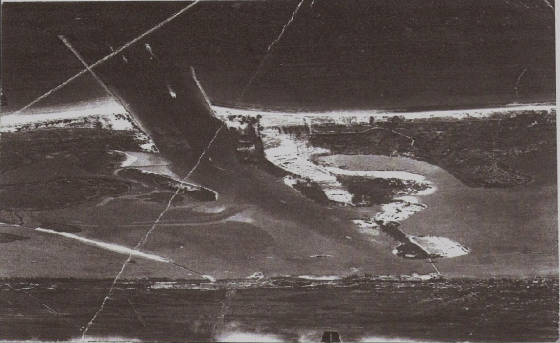
A 1940's vintage aerial photo of the inlets is below. The ocean is at the top of the photograph, and several boats can be seen entering the inlet.
In 1945, after WWII, there was a Congressional effort to both widen and deepen the Intracoastal Waterway. However, the funding bill failed to pass on an annual basis from then until 1950 after President Truman yacht (most likely the Sequoia) got stuck at Vero Beach for several hours with the President on Board. The former secretary of the Navy, Jon L. Sullivan, was also stuck there on his yacht at about the same time. Subsequently the funding bill passed and the channel depth was increased to at least 12 feet. Congress is still reticent to fund the channel maintenance and there are more depth issues in Georgia and South Carolina. This information was pulled from an article Janie Gould wrote on this matter after interviewing Vero Beach mayor, Alex MacWilliam.
A modern 4 lane highway bridge was not built until 1974. It was named the Peter P. Cobb Bridge. Peter Cobb had been an early Fort Pierce entrepreneur, was an alderman on the city’s first formal government, and was the first city clerk. North Hutchinson Island was not accessible by bridge from the Ft. Pierce area before WW II. The first bridging to North Hutchinson Island was a “swing span bridge.” It had a house atop the structure that operated the bridge. That bridge was operated 24 hours a day starting in 1947 until its drawbridge replacement was operational.
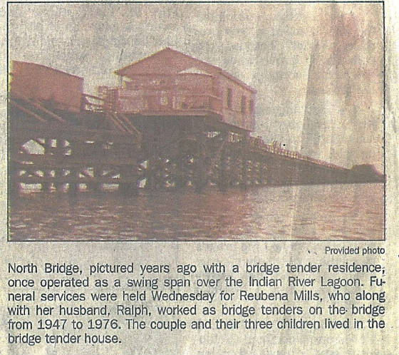
The same family, Reubena and Ralph Mills, lived in the bridge house and operated the bridge the entire time. That bridge initially led to gravel/sand roadways with the east/west portion being Royal Palm Way, later called Shorewinds Drive, and that roadway led to the north/south section called Atlantic Avenue. Paving of A1A didn’t occur until 1956. What became known as the North Bridge was built as a draw bridge to replace the swinging bridge and was commissioned the “D. H. “Banty” Saunders Bridge in 1965. That bridge has had millions of dollars spent on it for refurbishments, but remained a drawbridge in 2013 with another multi-million dollar refurbishment planned summer of 2015 planning in process for 2018/19 construction. When it was refurbished in 2003 for over $7 million and totally closed for a month, the state had plans that indicated it would be replaced by a fixed span by 2018. There is another small bridge on A1A less than a half mile east of the draw bridge. That’s called the “Little Jim Bridge”. Originally there was a wooden bridge spanning this waterway and it was collapsed by a heavy dump truck in 1962. A portion of that wooden bridge remains as a fishing pier at the Little Jim Bait and Tackle Shop. Seems nobody knows who the Jim was whose name adorns these places.
Stories of the tremendous fishing in the early days of Hutchinson Island abound among the old timers. The fish were large and plentiful, both in the river and the ocean. There were no limits or seasons to contend with and many people made a living in the fishing industry. As the abundance of fish diminished the controls emerged to try to restrain the depletion of the various native fish. Seasons, slot size limits, keeper limits, with some applying by specific location, some continually changing all emerged, so that it difficult to stay abreast as to what legal fishing limits really are. Many people made a living in the commercial fishing arena. Steve Lowe was one of those fabled for both his fishing prowess and commercial activities. Some called him king of the kingfish fisherman. He was born in Florida and grew up on the waterfront, his father having a fish house on the mainland side of the south bridge. Steve created the commercial fishing establishment at the northwest end of the south bridge. That’s the area undergoing major upgrade in 2013. Harvesting of eatable water creatures was not limited to fish, for oysters, crabs, shrimp, clams and lobsters were plentiful and were in demand.
Many living creatures inhabit or have inhabited the island over the years, some endangered and some now extinct. Raccoons, possums, squirrels, rabbits, rats, otters, and land crabs are the most frequently seen in modern times. There is an occasional bobcat and scattered reports of a Florida panther. A 4-6 foot alligator is seen swimming in the river occasionally, but the river is salt water and the gators don’t thrive in it. Several kinds of sea turtles, some weighing a ton, use the island beaches for nesting. Lighting in coastal turtle nesting areas is now controlled during their nesting season so as to not confuse the turtles to move toward the lighting rather than back to the sea. There are reports that a species of a small bear inhabiting the island, but was hunted to extinction by 1900. Many kinds of warm weather and water birds abound. There are many sanctuaries and preserves in Florida and several on North Beach.
|
Enter supporting content here |